


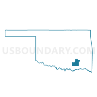
Voting District 1, Atoka County, Oklahoma
About
Outline

Summary
| Unique Area Identifier | 653483 |
| Name | Voting District 1 |
| County | Atoka County |
| State | Oklahoma |
| Area (square miles) | 4.76 |
| Land Area (square miles) | 4.61 |
| Water Area (square miles) | 0.15 |
| % of Land Area | 96.81 |
| % of Water Area | 3.19 |
| Latitude of the Internal Point | 34.40066690 |
| Longtitude of the Internal Point | -96.15337290 |
Maps


Graphs
Select a template below for downloading or customizing gragh for Voting District 1, Atoka County, Oklahoma


Neighbors
Neighoring Voting District (by Name) Neighboring Voting District on the Map
- Voting District 11, Coal County, OK
- Voting District 2, Atoka County, OK
- Voting District 3, Atoka County, OK
- Voting District 4, Atoka County, OK